30 April 2015
OMEGA - the world's first global electronic navigation system
The fascinating history of global navigation technologies includes the building of a radio antenna tower at Woodside in Victoria.
The construction of the Woodside OMEGA Tower was completed in 1978 and was one of eight towers positioned around the world.
The mast is Australia’s tallest man-made structure (Wikipedia) and stands at 1,400 feet (427 metres) and was part of the now redundant OMEGA real-time global navigation system which was switched off worldwide at exactly 0300 Zulu on 30 September 1997.
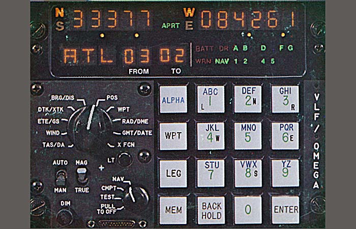
OMEGA was the first truly global radio navigation system, operated by the United States in cooperation with six partner nations. It provided ships and aircraft with the means to determine their position by receiving very low frequency (VLF) radio signals in the range 10 to 14 kHz, transmitted by a network of fixed terrestrial radio beacons. A receiver unit receives the transmitter signals and displays data that can be used (with the aid of charts) to fix a position. It became operational around 1971 and was shut down in 1997 since being made redundant by the more accurate and faster Global Positioning Satellite system.
Very Low Frequency (VLF) was chosen for the navigation system as low frequency (long wavelength) signals can propagate over very long distances following the curvature of the earth.
Although there existed other more accurate navigation systems (including the US TRANSIT satellite navigation system) until GPS was introduced OMEGA was the only real-time system with global coverage.
OMEGA’s design accuracy was 2 to 4 nautical miles (3.7 to 7.4 km) compared to GPS which now provides accuracy within a few metres and providing immediate LAT & LONG coordinates as well as the ability to determine altitude.
How OMEGA navigation worked
The system used radio frequencies and phase difference calculations to determine global position. A network of eight (VLF) transmitter sites spread around the globe made up the system.
The underlying principle to calculate position is common to most terrestrial navigation. If you know the position of TWO fixed reference points and YOUR distance from each then through plotting the intersection point on a map, you will be in ONE of TWO possible locations, either above or below the line joining the two fixed reference positions. Having a third reference position resolves the above/below the line ambiguity.
OMEGA provided EIGHT fixed reference positions and finding the distance to each transmission tower was achieved using the propagation speed of the radio signals - sort of.
Eight transmitter stations positioned equally around the Earth (at eight-pole points) provided usable signals from at least five stations. All of the transmitters were synchronized to a local Cesium clock (highly accurate having a drift of about 1 second in 30 million years) at each station and emitted signals from each base station in a pre-determined sequence.
Each Omega base station transmitted a sequence of three very low frequency (VLF) signals plus a fourth frequency which was unique to each of the eight stations. The duration of each pulse differed in a fixed pattern, and repeated every ten seconds; the 10-second pattern was common to all 8 stations and synchronized with the carrier phase angle, which itself was synchronized with the local master atomic clock. The pulses within each 10-second group were identified by the first 8 letters of the alphabet (A, B, C, D, E, F, G, and H).
The individual pulses were used to establish a receiver's internal timing within the 10-second pattern. However, it was the phase of the received signals within each pulse that was used to determine the transit time from transmitter to receiver (thus yielding a distance measurement). Using hyperbolic geometry a position fix with an accuracy of 5–10 kilometres (3.1–6.2 mi) was achievable over the entire globe at any time of the day.
Initial use of the OMEGA system required first knowing the journey starting point by using a known accurate map reference and then taking regular OMEGA readings to update the position. Chart plotting was required to manually plot the points of intersection between transmitter signals. However, later with the introduction of digital logic including microprocessors, automated receivers were developed that provided a digital LAT & LONG readout and used local signal correction and differentiation to improve accuracy.
While not accurate enough to (for example) guide an aircraft to the start of the runway (modern GPS can), they were useful in guiding aircraft across oceans and continents, and for marine navigation.
Why is the Australian OMEGA Tower being demolished?
Since OMEGA was switched off in 1997, the tower was used for submarine communication. However, that too was discontinued and since the tower has no purpose it has remained as a deteriorating (and very tall) relic.
The decision to demolish the tower was instigated by the (then) Federal Member for Gippsland Daren Chester. Following the tragic death of a BASE jumper at the site 12 months ago. Mr Chester sought advice from the Department of Defence on the future use of the tower.
Tenders are being called for the demolition of the tower and the rehabilitation of the site. Interest will be high in the extensive grid of copper rods buried beneath the tower to create an equipotential ground (“earth”) base for the transmission antenna.
The final decision to demolish is subject to reviewing the tower’s heritage significance.
Update: 22 APRIL 2015
The Tower was demolished by explosives on 22 April 2015.
VLF Transmitter Woodside [Wikipedia]
More information
ABC Online - Australia's Tallest Structure to be demolished
Silicon Chip Online Article - “How Omega Ruled The World Before GPS” by David Maddison